GC,
You're good at ancient metaphysics! Stick to that! Meanwhile keep asking questions.

Often I guess we assume that a person interested in this thread probably has some background or research behind them, so we give these short, less than explanatory answers as "reminders" perhaps of what they should already "know"...
So here's a more complete answer:
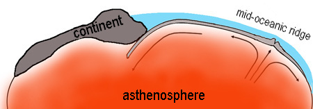
Seasmith provided you with a [not too comprehensive] illustration that RM would refer to as a cartoon of seafloor spreading. There are lots better "cartoons" than that, and Wikipedia has a pretty comprehensive write-up on "Mid-Ocean Ridge" that will help you. I'll paraphrase some main ideas here: What was known as the mid-ocean ridge or rift after it was encountered during the laying of transatlantic cables back in the 19th C. became understood more as a "spreading" zone in the late 1960s with the discovery of many bands of somewhat magnetic striping symmetrically along both sides of it. This has been given as evidence, further verified by GPS measurements [and other survey data] of continental movements away from it, eg. that the Americas are moving west and Europe and Africa are moving east with respect to the rift. (Wegener explained this in his original development of the theory in 1912; without sufficient survey data to confirm it, his idea was mostly dismissed.) Subsequently the ridge was found to extend globally, however without the symmetrically arranged coastlines running to the east and west of it as in the Atlantic. What has been understood and repeatedly confirmed for over a century is that the mid-ocean ridges are zones of extrusive and seismic activity. Look at the Island of Iceland, a continually erupting region where the Mid-Atlantic Ridge has done just what you said, extruding itself upward out of the ocean. The rift extends across the middle of the island where it may be plainly seen as just that, an opening in the earth's crust. See Wiki for more.
That's standard understanding; here's some
webolife:
The magnetic striping has been given as evidence for magnetic field reversals in earth history, but there are other interpretations that I think are more obvious from the standpoint of a catastrophist. First it must be understood that while the ferrous crystals in basalts along the ridge are oriented largely in one [northish] direction or the other [southish], in a somewhat alternating fashion as you measure away from the ridge either to the east or west, there is a significant range of orientations that must be averaged out to come to the conclusion of "reversal". Since these "stripes" demark different flows in a reasonably symmetric manner "right" and "left" of the ridges, it is understood that the flows represent recurring eruptions over time that flowed away from the rift zone. In the gradualist view, the ferrous minerals aligned as the basalt hardened, as natural and synthetic magnets are known to do, freezing the crystals into their positions. Millenia or eons later new flows did the same with the "new" magnetic field vectors frozen in their "reversed" orientations. This happened dozens of times. Age dating the flows is somewhat problematic but in general it can be shown the flows further away from the rift are older than flows near the rift. That is a horizontal distribution of age which has more than one interpretation, but the simplest is that the ocean crust has moved [is moving] away from the ridge over time, as new material is being added at the rift. Now if those flows were as occasional and infrequent and that movement was as slow as observed today, then the stripes indicate a series of large scale shifts ["reversals"] in the earth's magnetic field. But what if it happened at a much greater rate in the past? Picture bands of lava pouring out into the inwashing seas that filled the separating continents. They begin to cool almost immediately but not evenly, so the ferrous orientations are not entirely set. Not long afterward more bands of lava flow out over and "behind" the previous bands. The crystal orientations of the new material now have the influence of the earth's magnetic field, but also the influence of the previously magnetized basalt flows. Naturally heads will orient toward tails and tails toward heads [NS and SN] causing the flows to appear "reversed" [very roughly of course]. In this scenario the magnetic striping doesn't have time to react to some age long shift in the earth's field, but still shows "reversal" due to the orientation of the magnetic material it is contacting. Since the rift zones are not in the center of the other ocean basins but toward a side, even extending in some places over onto continental crust [as in the San Andreas fault in California], that tends to play against the "expanding earth" hypothesis as I see it. More significantly the continental drift away from the spread centers put into play the bulldozing of the continents at their leading edges as they pushed against the Pacific Ocean crust, resulting in the lifting of the plateaus, and characteristic boundary ranges and island arcs and trenches. That this happened as a "single" worldwide phenomenon is evidenced I believe by the globally interconnected system of the mountains and ridge zones that we observe.