It irritates me when the accompanying photo is utterly worthless!'These stones have been laid out precisely to map the sun,' said astrophysicist Professor Ray Norris, who is based at Australia's Commonwealth Scientific and Industrial Research Organisation in Canberra.
Archeology and Ancient Human Activity
-
StevenJay

- Posts: 506
- Joined: Thu May 01, 2008 11:02 am
- Location: Northern Arizona
Were Aborigines the First Astronomers?
It's all about perception.
-
fosborn
- Posts: 194
- Joined: Mon Nov 30, 2009 7:53 pm
Re: Were Aborigines the First Astronomers?
http://www.aboriginalartonline.com/art/aimages/mimi.jpg
Based on EU this might interest you. I got called into work and am on my phone, so uplaoding the picture is a bit much.
Hey it worked!
Based on EU this might interest you. I got called into work and am on my phone, so uplaoding the picture is a bit much.
Hey it worked!
-
HelloNiceToMeetYou

- Posts: 53
- Joined: Sun Sep 05, 2010 11:51 am
Re: Were Aborigines the First Astronomers?
That definitely is a plasma phenomena. That and the tree of life, must of been some kind of electrical discharge in the early atmosphere. It is so prevalent throughout the whole world. Either that or Aliens. I am leaning towards the Plasma explanation 
-
fosborn
- Posts: 194
- Joined: Mon Nov 30, 2009 7:53 pm
Re: Were Aborigines the First Astronomers?
I blew it. I'm at home on my PC now. 
Looking at his link, they should at lest took the picture with the sun out.
But its still pretty cool, for 10,000 year old.
Could this have some implications for Saturn Theory ( alignment of the sun at that time in history)?
Or would the cataclysmic events cast doubt on radiological clocks ( being reset under global plasma events) to question this age estimate?
'This can't be done by guesswork. It required very careful measurements.'
Professor Norris said the Aborigines who laid out the stones would have made their crude ground map around 10,000 years ago - thousands of years before Stonehenge and the pyramids of Egypt.
Scientific studies are continuing on the rocks, which have been laid out in a semi-circle, with two points set in perfect alignment with the setting sun on a midsummer's day.
http://www.dailymail.co.uk/sciencetech/ ... s-ago.html
-
moses
- Posts: 1111
- Joined: Wed Mar 19, 2008 3:18 pm
- Location: Adelaide
- Contact:
Re: Were Aborigines the First Astronomers?
That definitely is a plasma phenomena. That and the tree of life, must of been some kind of electrical discharge in the early atmosphere.
HelloNiceToMeetYou
Excuse me, but why cannot this phenomena be beyond the atmosphere, perhaps in the ionosphere or beyond the Earth's magnetosphere.
Mo
HelloNiceToMeetYou
Excuse me, but why cannot this phenomena be beyond the atmosphere, perhaps in the ionosphere or beyond the Earth's magnetosphere.
Mo
-
tholden
- Posts: 934
- Joined: Wed Jul 02, 2008 6:02 pm
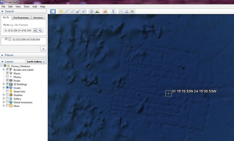
Likely Major City Found off African West Coast
People ask where did the waters of the flood go..... Basic answer seems to be that they didn't go anywhere and that most antediluvian major sites of human habitation are still beneath the waves. Some guy just stumbled on this one with Google Earth:
http://www.telegraph.co.uk/technology/g ... frica.html
http://www.telegraph.co.uk/technology/g ... frica.html
-
GaryN

- Posts: 2668
- Joined: Tue Apr 01, 2008 8:18 pm
- Location: Sooke, BC, Canada
Re: Likely Major City Found off African West Coast
Google engineers say it is a sonar scanning artifact. It would need independent research to
disprove them.
http://www.thunderbolts.info/wp/forum/phpB ... abd#p29787
disprove them.
http://www.thunderbolts.info/wp/forum/phpB ... abd#p29787
In order to change an existing paradigm you do not struggle to try and change the problematic model. You create a new model and make the old one obsolete. -Buckminster Fuller
-
Siggy_G

- Moderator
- Posts: 501
- Joined: Sun Dec 21, 2008 11:05 am
- Location: Norway
Re: Likely Major City Found off African West Coast
Strange, it doesn't appear as digital image artifacts at all, while it does come through as a city layout. Digital image artifacts usually appear like straight lines or blocks of messed-up data, and not organic semi-straight lines with the exact embossed shading as the rest of the image (could be Google does the shading artificially after they receive the height map data). Than again, why should roads be the carved-in remains, while any signs of buildings/temples be flattened?
Artifact example 1
Artifact example 2
Artifact example 1
Artifact example 2
-
MrAmsterdam

- Posts: 596
- Joined: Tue Oct 27, 2009 8:59 am
Re: Likely Major City Found off African West Coast
Guys, the same newspaper reported this later,
http://www.telegraph.co.uk/technology/g ... lines.html
Google Ocean: Atlantis 'found off Africa' turns out to be boat mapping lines
Hopes that a 'grid of streets' of the lost city of Atlantis had been found on Google Ocean have been shattered.
-
-
A spokeswoman said: "It's true that many amazing discoveries have been made in Google Earth including a pristine forest in Mozambique that is home to previously unknown species and the remains of an Ancient Roman villa.
"In this case, however, what users are seeing is an artefact of the data collection process.
"Bathymetric (or sea floor terrain) data is often collected from boats using sonar to take measurements of the sea floor.
Today's scientists have substituted mathematics for experiments, and they wander off through equation after equation, and eventually build a structure which has no relation to reality. -Nikola Tesla -1934
-
Siggy_G
- Moderator
- Posts: 501
- Joined: Sun Dec 21, 2008 11:05 am
- Location: Norway
Re: Likely Major City Found off African West Coast
Yep, and that was what I responded to in my post aboveMrAmsterdam wrote:Guys, the same newspaper reported this later,
-
Lloyd
- Posts: 4433
- Joined: Fri Apr 04, 2008 2:54 pm
Re: Likely Major City Found off African West Coast
* I saw similar lines in a number of places on ocean floors a couple years ago. I recalled that there were some off the U.S. west coast, so I just had a look and, yup, there they still are. Except Google may have smoothed them out a little. I used to see strips that had higher definition next to areas with less definition and the interface looked like these lines. But now I don't see the strips of high next to low def, just the lines.
* Check this out off California: http://maps.google.com/maps/mm?hl=en&ie ... 04&t=h&z=8.
* This is off Washington: http://maps.google.com/maps/mm?hl=en&ie ... 064209&z=7.
* It's possible that they're real, but, if so, they're not roads. They'd be rather large trenches or valleys.
* Here are lines north of Hawaii: http://maps.google.com/maps/mm?hl=en&ie ... 128418&z=6.
-
Osmosis
- Posts: 423
- Joined: Wed Mar 19, 2008 3:52 pm
- Location: San Jose, California
Re: Likely Major City Found off African West Coast
The so-called Atlantis area was a bottom survey, to locate places to dump rad-waste.
-
MrAmsterdam
- Posts: 596
- Joined: Tue Oct 27, 2009 8:59 am
Re: Likely Major City Found off African West Coast
Did they (?) already dump radioactive waste in the atlantic area?Osmosis wrote:The so-called Atlantis area was a bottom survey, to locate places to dump rad-waste.
Today's scientists have substituted mathematics for experiments, and they wander off through equation after equation, and eventually build a structure which has no relation to reality. -Nikola Tesla -1934
-
Osmosis
- Posts: 423
- Joined: Wed Mar 19, 2008 3:52 pm
- Location: San Jose, California
Re: Likely Major City Found off African West Coast
Watch where you go swimming! 
-
nick c

- Site Admin
- Posts: 2483
- Joined: Sun Mar 16, 2008 8:12 pm
- Location: connecticut
Re: Recovered: Tiahuanacu (was Researcher claims vast N/W ....
This thread is a combination of the following threads:
Likely Major City Found off African West Coast
Submerged ancient caves, pyramids, sites, cities, etc.
Another submerged city reported
Stone Circles and Rings with smaller Rim-Rings
Arctic Scarring?
Recovered: Tiahuanacu (was Researcher claims vast N/W ....
Mysterious Electrified Forest Rings of Northern Ontario
Pictographs of central Oregon
Who is online
Users browsing this forum: No registered users and 0 guests