THOTH CLUES TO THE GREAT FLOOD Part 2
http://saturniancosmology.org/files/tho ... 999.01.txt
MARS ROCKS IN ANCIENT MYTH AND MODERN SCIENCE: Part I of II By Ev Cochrane
... To date, ten Martian meteorites have been identified [on Earth], half of them being observed falls. ... Reviewing the history of meteoritics, Dodd commented ...: "That meteorites came from beyond the Earth is both a very old and a new idea.... The ancient Greeks and Chinese also regarded meteorites as objects from the heavens, but this perception, like so much else of value, was lost to Western culture during the long intellectual night that we call the Dark Ages."
... Immanuel Velikovsky claimed that rocks from Mars had only recently menaced the Earth. Velikovsky drew this conclusion upon the basis of ancient testimony, which described Mars as participating in spectacular cataclysms involving the Earth and various neighboring bodies. In Worlds in Collision, Velikovsky described the events associated with the near passage of Venus and Mars as follows: "When Mars clashed with Venus, asteroids, meteorites, and gases were torn from [Venus' comet-like tail], and began a semi- independent existence, some following the orbit of Mars, some other paths. These swarms of meteorites with their gaseous appendages were newborn comets; flying in bands and taking various shapes, they made an uncanny impression. Those which followed Mars closely looked like a troop following their leader. They also ran along different orbits, grew quickly from small to giant size, and terrorized the peoples of the earth."
... Most of these rocks contain iron-rich silicates and iron oxides, clear evidence that they were created in a rather iron-rich environment. ... [T]he crystallization age[s] were on the order of ~1.3 billion years [younger than any other meteorites].... Rare earth element analysis ... suggests a source region pressure of >40 kbars.... The individual minerals show some disturbance at ~180 million years in the U-Pb, Rb-Sr, and Ar-Ar clocks. This is thought by some to represent the date of impact.... According to McSween, "the measured abundances and isotopic compositions of Ar, Kr, Xe, and N are unique among meteorites and closely resemble the composition of the Martian atmosphere analyzed by Viking." Dodd [said] "the only plausible explanation ... is that the meteorite trapped these atmospheric gases during shock melting."
... SCENARIOS OF EJECTION AND TRANSPORT
... "The key unresolved question is whether an impact could eject >10-m blocks from Mars with velocities in excess of the escape velocity of 5 kmp[/s]."
... McSween summarizes the problem as follows: "It has generally been supposed that any smaller fragments that could be ejected from planets by impact mechanisms would have experienced such a high degree of shock that they would be pulverized, melted, or even vaporized. Yet no other natural means of meteoroid ejection seems possible. The energy of rapidly expanding gases during volcanic eruptions is too small to accelerate fragments to planetary escape velocities, and other geologic phenomena are even less capable launching mechanisms." ... Vickery and Melosh [said]: "The dynamically most plausible explanation for the martian origin of the SNC meteorites is that they were ejected from Mars in a single, very large magnitude event ~200 Ma ago." ... [T]he cosmic ray exposure ages of the respective meteorites ... [ranges from] .5 m.y. [to] 11 million years.
... One possibility-discussed by Vickery and Melosh-is to assume that the [meteorites] were originally part of a much larger body which subsequently became fragmented in space at times corresponding to their cosmic-ray exposure ages.
... [But] it is more likely that SNC meteorites were ejected from Mars in three considerably smaller impact events at times corresponding to the three groups of cosmic ray exposure ages.... Other problems arise from the fact that the various SNCs experienced different degrees of shock [from] intense [to none]. ... According to Dodd, the finding of lightly shocked lunar meteorites in Antarctica alleviates - but does not entirely remove - the [problem].
... H. Melosh, an early critic of the idea that the SNCs could be Martian in origin, offered a model whereby it is possible for planetary impacts to eject a requisite amount of near-surface material without significant shocking through a process known as spallation. ... "Rocks very near the ground surface experience several kinds of shock waves that partially cancel each other. ... Calculations indicate that some of this near-surface material will spall off as relatively unshocked fragments and can be accelerated to high speeds."
http://saturniancosmology.org/files/tho ... 999.02.txt
MARS ROCKS IN ANCIENT MYTH AND MODERN SCIENCE: Part II
... The Ancient Testimony
... Mars was worshipped by most ancient peoples. ... Indeed, Mars was associated with spectacular disasters of one form or another, not the least of which was a great flood of water descending from the sky. ... I have confirmed that the ancients described Mars as being much closer in recent times, close enough, in fact, to dominate the skies. Various Babylonian omens, for example, associate Mars with prodigious eclipses of the Sun. ... f Mars only recently moved upon a different orbit, one much closer to the Earth, the Babylon reports become easier to understand. And the same is true with regards to the presence of Martian meteorites upon terrestrial landscape. Is there any ancient testimony associating Mars with meteorites, or with the hurling of stones from heaven? Indeed there is, and it is quite compelling. The most extensive analysis of the ancient traditions surrounding meteorites is that of Judith Bjorkman. Bjorkman showed that the ancient Babylonians, among others, held surprisingly sophisticated views about the nature of meteorites. Bjorkman summarized her findings as follows: "The texts show that the peoples of the ancient Near East knew of and were able to describe shooting stars, meteors, fireballs, meteor showers, and comets. They were also aware of the extraterrestrial origin of meteorites, including iron meteorites." ... Suffice it to say that the ancient Babylonians specifically referred to meteorites falling from the planet Mars, making such objects the subject of various omens. ... If such reports reflect reliable eye-witness testimony - the view defended by Bjorkman - and meteorites were indeed witnessed emanating from or circling Mars, it stands to reason that the various gods identified with the red planet might likewise be associated with the hurling of rocks, with celestial demons of one form or another, or with various other phenomena typically associated with the fall of meteorites. And such is indeed the case.
... Nergal and Indra
... The dreadful war-god Nergal - expressly identified with the planet Mars - is associated with a demonic entourage in various Babylonian texts. Thus, an early hymn to Nergal invokes him as the "leader and sender of evil demons." A hymn quoted by Velikovsky describes the cohorts of Nergal/Mars as follows: "Great giants, raging demons, with awesome numbers, run at his right and at his left." ... Nergal is elsewhere described as hurling great rocks from heaven. A hymn translated by Bollenrucher reads as follows: "You hurl the towering stone, shattering all plants." ... Like Nergal/Mars, Indra was intimately associated with eclipses of the "Sun" and various other extraordinary celestial disturbances. And like Nergal, Indra was described as hurling great bolides. Indra's celestial missiles were described as follows in one Vedic hymn: "Thou hurlest forth from heaven the iron missile." A similar passage is the following: "And men have faith in Indra, the resplendent one, what time he hurleth down his bolt, his dart of death." ... As is well-known, Indra's weapon of choice was the vajra, typically understood as a thunderbolt. Indra's heaven-hurled weapon, however, is elsewhere said to be composed of metal or stone. Here Gonda observes: "Although Indra's weapon is usually explicitly designated by the term vajra, and vajra is generally described as metallic (ayasa), it is incidentally spoken of as a rock (parvata) or 'stone of, or from, the heavens (divo asmanam)."
... Blinkenberg ... in his landmark study of the thunderweapon in ancient lore, summarized the ancient conception of lightning as follows: "The lightning, then, is produced by a stone which shoots down from heaven to earth." Meteors, in accordance with this belief, were identified with thunderstones throughout the ancient world. G. Wainright, surveying the conceptions of the ancient Egyptians, concluded that: "In religion the meteorite and the thunderbolt are the same thing." Virtually identical beliefs prevailed in aboriginal Mesoamerica. If the original reference for Indra's heaven-hurled bolt was to a meteor-like object, both descriptions of the vajra-rock and metallic rock-would be equally appropriate, many meteorites being composed of iron. The planet Mars, moreover, was regarded as the iron-planet par excellence by ancient skywatchers and medieval alchemists alike. ... [V]arious passages in the Rig Veda relate that Indra's gargantuan form dominated the skies, extending from heaven to earth.
... Gonda points out that, "both parts combine so as to form a ketu (which may mean ... 'an unusual phenomenon such as a comet or meteor')." ... Also relevant here is Indra's intimate association with the Maruts, described in the Rig Veda as a celestial troop, as "men of heaven". It is with the aid of the Maruts that Indra accomplishes his greatest feats. ... [T]he Maruts are said to shine in heaven like blazing fires, or like brilliant snakes. ... "At their coming heaven ... roars with fear" recall[ing] the terrible noise which frequently accompanies meteorites as they enter the Earth's atmosphere? ... A Vedic hymn quoted by Velikovsky reads ...: "You the powerful, who shine with your spears, shaking even what is unshakable by strength ... Hurling the stone in the flight ... All beings are afraid of the Maruts. May your march be brilliant, O Maruts ... Shining like snakes. ... They gleam with lightning, Heroes, Casters of the Stone, wind-rapid Maruts...."
... Rudra
The Maruts are elsewhere associated with the war-god Rudra, the latter known to share numerous features in common with Indra, various authorities suspecting an original identity of the two gods [with Mars]. ... The demonic [Maruts], like Rudra himself, were described as riding the wind, roaring, and being of a brilliant red color. ... [F]rom the Rig Veda: "... Him with the braided hair we call with reverence down, the wild-boar of the sky, the red, the dazzling shape. ... To him the Marut's father ... Far be thy dart that killeth men or cattle...." ... As the red boar of heaven, Rudra is to be identified with the planet Mars. His very name reflects ... an ancient word for "red" or "ruddy".
Evidence of Ancient Global Cataclysm
-
Lloyd
- Posts: 4433
- Joined: Fri Apr 04, 2008 2:54 pm
Re: Evidence of Ancient Global Cataclysm
Last edited by Lloyd on Tue May 31, 2016 8:13 am, edited 3 times in total.
-
Lloyd
- Posts: 4433
- Joined: Fri Apr 04, 2008 2:54 pm
Re: Evidence of Ancient Global Cataclysm
THOTH CLUES TO THE GREAT FLOOD Part 3
http://saturniancosmology.org/files/tho ... 999.08.txt
SATURN CONFIGURATION DISCUSSION
... CARDONA: ... If the Saturnian system was NOT captured by the Sun, the advent of day and night would have commenced at the clearing of the Saturnian nebular cloud within which the Saturnian system was enshrouded. In any case, whether the Saturnian system was, or was not, captured by the Sun, the Saturnian nebular, or placental, cloud would still have shielded the Sun from view until after Saturn's flare-up which, among other things, blew the placental cloud out of existence.
... ROBERT PREVIOUSLY: At what point does massive flooding come into the scenario? Do you believe that great quantities of water fell from the sky and/or world pillar in conjunction with the break-up?
CARDONA: >From the world pillar during the break-up, definitely ... [over not] even a century.
http://saturniancosmology.org/files/thoth/thotiv01.txt
THE DEMANDS OF THE SATURNIAN CONFIGURATION THEORY: Part III
Excerpts from Dwardu Cardona's SIS Silver Jubilee Paper
... CARDONA: THE WHIRLING COLUMN
Once again, I cannot here present the entire string of evidential sources which attest to the whirling motion of the cosmic pillar. Instead I will merely present the opinion of four authorities on the subject. DC Santillana and von Dechend are two of many who came to the conclusion that the [visible Earth's] axis did twist and turn -- although they seemed somewhat unsure of whether it did so slowly or rapidly -- even if to them the axis was anything but an actual physical entity. So, incidentally, did Elmer Suhr when he speaks of the 'whirling cosmic column' and 'the whirling column of the cosmos.' In fact, Suhr goes on to stress: 'It is especially important to think of the cosmic column not as a static post but as a constantly whirling crucible...' Talbott, of course, also recognized this fact when he wrote that 'the cosmic mountain in many creation epics is presented as a churning, serpentine column rising along the world axis...' t is more than obvious from descriptions of the Saturnian axis, as well as prehistoric Petroglyphs, that the polar column was a visible entity rather than a deduced abstraction. This was so much so that, in some cases, the axis was even pictured as a ladder reaching to the Saturnian sun. ... It is ... this bolus flow that would have given the planetary tornado, or Rankine vortex, its serpentine quality.
... THE WATERY VORTEX
AMY: Cardona proposes, if the polar column were actually a colossal tornado, that the Saturn theory demands that this, too, should be part of the mytho-historical record. ... [T]he tornado would have sucked large amounts of waters from the Earth and ancient man should have been aware of this, if not from observing the column itself, then at least from observing what happened when the column was severed.
CARDONA: [A]mong the Australian Aborigines, the great python is the most impressive representative of the polar column. It is therefore significant that this python is not only believed to tower up to the level of the clouds, but that he also 'brings about rain and flood.' The Efe pygmies of the Ituri forest tell of a deluge of water which gushed forth as a mighty river when their version of the Cosmic Tree, which was the polar column, was felled. Similarly, the Arawak Indians of the [Guianas] tell of a wondrous tree which Sigu cut down. From its stump, water gushed out in such quantity as to cause a deluge. This tale is also found among the traditions of the Cuna, who tell of their mischief-maker, the Tapir, chopping down the Saltwater Tree from which salt water gushed out to form the oceans of the world. Thus, Velikovsky was correct when he surmised that the water of the Deluge would have been salty, but not, as he believed, because the salt, or at least its chlorine content, originated from Saturn. The water was salty because it came from the same oceanic water the vortex had sucked up in the first place.
... THE FLOOD FROM THE NORTH
AMY: Cardona moves on to the next demand of the Saturn Theory. If the Deluge was [partly] the result of the collapse of a colossal tornado situated in the north, then the mytho-historical record must also contain this information. And it does. Among others, three American Indian tribes, the Wintus, the Wichita, and the Pawnee, tell different legends of the flood, but in each case the deluge arrives from the north.
CARDONA: But what of the hard sciences? Is the evidence there? Once again, I can only mention a few items here, but that an enormous flood had once swept down from the north to scour the land surface of North America has been suggested by J. Harlan Bretz. So, similarly, with C. Warren Hunt who speaks of evidence pointing to a flood from the north, excavating the land as it went before it emptied into Lake Bonneville. That Lake Bonneville itself also burst its bounds to cause a secondary flood has been documented by Robert Jarred and Harold Malde. What is of additional interest here is that the area once covered by this lake constitutes a vast salt deposit 100 square miles [= ten miles square] in extent. Similar signs of a vast scouring flood from the north have also been discovered in Siberia. ... [T]his flood was [not] due to the catastrophic melting of the northern ice cap at the end of the Ice Age [since, at that] time, the northern ice cap had not yet been formed.
... THE CHURNING OF THE OCEAN
... [T]he Indic myth from the Mahabharata and the Bhagavata Purana [says]: In an effort to produce ... divine nectar, both gods and demons used Mount Mandara as a churning stick. Winding the serpent Vasuki, [or] Ananta, around Mount Mandara, ... depicted not in the form of a mountain, but in that of a pillar ... the gods (at one end) and the demons (at the other) grasped hold of Vasuki by the head and tail and, pulling him back and forth, were able to rotate Mount Mandara fast enough to whisk the sea into an ocean of milk from which amrita was produced. ... [T]hus ... the mythic World Mountain and the Axis Mundi were one and the same. In fact, it has long been known to Indologists that Mount Mandara stood for the axis of the world. ... In Vasuki we recognize the bolus flow wrapped around the central vortex -- and here it is interesting to note that this entity was 'associated with the north,' thus locating the entire action in that locality. Finally, in the divinities' churning by pulling at the coiled Vasuki this way and that way, an echo is retained of the clockwise/counterclockwise rotation of the bolus flow as described by Jueneman.
... The elements contained in the myth of the churning of the ocean must not be thought of as uniquely Hindu in origin. In the Hindu myth, for instance, we see that Mandara was placed on the back of a tortoise. In Chinese mythology, it is Shang-ti who is depicted as standing on the celestial tortoise, while the serpent was said to have encircled the tortoise. Shang-ti's title was The Holy and Propitious Prince of the North Pole, who is usually represented as surrounded by a halo, both of which have special meaning to this study. It is also noteworthy that the symbolism of the tortoise and serpent goes at least as far back as the Han dynasty and was used as an emblem for the northern region of the world. More than that, as Lord of the Centre, Shang-ti was also revered as Huang-ti, who is perhaps better known as the Yellow Lord or Yellow Emperor. The Yellow Emperor has long been acknowledged to be an avatar of Saturn. And in the Japanese Kojiki we learn of the Heavenly Jeweled Spear which joined heaven to Earth and which acted as the churning stick responsible for the surfacing of the mythical ... island of Onogoro [in the sky].
http://saturniancosmology.org/files/thoth/thotiv02.txt
THE DEMANDS OF THE SATURNIAN CONFIGURATION THEORY: Part II
... THE ARCTIC CARNAGE
... Arctic muck ... covers no less than one seventh of the land surface of earth, all of which ... lies within the Arctic Circle. Composed mainly of silt, sand, pebbles, and boulders, it is often accompanied by 'preserved, semi-decayed, or fully decayed vegetable and animal matter.' Its depth, in some places, 'has always caused even the most open-minded geologists to boggle.' The Russians, who have conducted prolonged studies on this muck, have in some places drilled down to more than 4000 feet without reaching rock bottom. Entire forests have been found buried in this area, including plum trees complete with their leaves and fruits, to say nothing of palm trees and huge exotic ferns ... [as well as animals like] the mammoth. ... [T]he Arctic Ocean [itself is] an immense basin scoured out of the living rock. [The north polar tornado/vortex did all that.]
... Entire forests in an uprooted condition, bituminous trunks and fossilized charcoal, are everywhere [in the Arctic] intermingled with petrified ash, and veins of ice, and sand that has turned into sandstone. Among this colossal devastation are found the skeletons of mammoths, rhinoceroses, bison, and horses.
... In the Mahabharata we read that Mandara, that churning mountain, was 'crowded with tusked animals.' Moreover, when the churning began, great trees spun off, were crushed against one another, lightning flashed forth, a fire blazed burning the elephants and other beasts, 'and all the various creatures there lost their life's breath.' The water pouring from above eventually dowsed the fire and flowed into the ocean.
... THE ONSLAUGHT OF ICE
... How did it all freeze? ... This is an easy question to answer. [The ancients] had long associated ... Saturn [on the polar vortex] with snow and hail, ... cold and moist, ... cold and windy, ... cold and frozen, [a] cold star. ... William of Conches ... tells us that 'Saturn is called cold not because he is inherently cold himself but because he causes cold.' ... [T]he Modoc Indians of southern Oregon and northern California [said] the Chief of the Sky Spirits drilled a hole in the sky with a rotating stone through which he pushed snow and ice to form a mound which almost touched the sky. ... Dolph Hooker informs us: "... we cannot find evidence that Earth's climate grew cold before the advent of an ice age; ... on the contrary, climate grew colder only after the ice arrived and only to the extent that the ice itself refrigerated the Earth.... Obviously the perma-frost accumulated from the bottom upward -- not by freezing from the top downward." What this means is that the detritus which forms the permafrost was frozen as it was being laid down. ... What I am claiming is that the snow, ice, and sleet came from the axial vortex when it was severed for the last time because that is where a vast quantity of terrestrial moisture had been stored.
... The Muria [tribe of] India tell without ambiguity how [the polar god] Mahapurub turned the world topsy-turvy. ... [The Hopi said] "The world, with no one to control it, teetered off balance, spun around crazily, then rolled over twice. Mountains plunged into seas with a great splash, seas and lakes sloshed over the land; and as the world spun through cold and lifeless space it froze into solid ice."
http://saturniancosmology.org/files/thoth/thotiv04.txt
THE NATURAL REFERENCES OF MYTH By Dave Talbott
... WARS OF THE GODS
As a mythical archetype, the Doomsday catastrophe is not merely a terrestrial disturbance, it is the story of celestial upheaval. The gods themselves battle in the sky so violently as to rearrange the heavens. Their weapons include thunderbolts and stone, flaming "arrows", fire-breathing dragons, and all-consuming wind and flood. The tale is most familiar to us, perhaps, as the famous clash of the Titans, recounted by Hesiod and other Greek poets. ... The wars of the gods occur during, or as, the "break" that separates the Golden Age from the subsequent epoch.
... DRAGON OF DARKNESS
Nothing could be further removed from our familiar experience than a flying serpent or dragon. And yet it was not long ago that every race on earth remembered the fire-breathing dragon moving among the stars, disturbing the motions of the planets, and threatening to destroy the world. ... The celestial serpent-dragon takes the form of a great storm or whirlwind, breathes fire and smoke, battles against the gods, and ushers in a period of universal darkness. ... It appeared specifically during the break between world ages -- following the death or departure of the Universal Monarch....
http://saturniancosmology.org/files/thoth/thotiv05.txt
WORLD MOUNTAIN By Dave Talbott
... [The tornado-aspect of the polar axis] ... needs to be distinguished from the column in its more stable or undisturbed aspect. ... The more violent phases certainly did present the APPEARANCE of a "tornado" overtaking the land of the gods. But the dynamics of a terrestrial tornado do not represent the situation particularly well when you have visible gases, ice, dust, or other material stretching BETWEEN PLANETS. A vortex cannot exist in isolation from the movement of a surrounding medium, while the polar column appears as a discrete, well-focused stream or jet of material retaining a consistent structure over a considerable distance. ... We know that electromagnetic frequencies ARE focused in a laser beam. We know that plasma focus devices DO produce well-defined jets and a flow of electric current on a linear path. ... [A]stronomers have recently discovered POLAR or AXIAL jets on a mind-boggling scale.... By comparison, the much, much smaller-scale axial jets in the Saturn model, where the charged bodies are planets, seem very tame indeed.
-
Grey Cloud
- Posts: 2477
- Joined: Sun Apr 13, 2008 5:47 am
- Location: NW UK
Re: Evidence of Ancient Global Cataclysm
Lloyd,
Just posted a link to an excellent little paper on aspects of the MBA collapse here:
http://www.thunderbolts.info/wp/forum/phpB ... 01#p113701
Note how they present their evidence - not just a bundle of unsubstantiated assertions and dubious facts; nor a dog's dinner of concatenated snippets from various myths lumped together.
If I have the least bit of knowledge
I will follow the great Way alone
and fear nothing but being sidetracked.
The great Way is simple
but people delight in complexity.
Tao Te Ching, 53.
I will follow the great Way alone
and fear nothing but being sidetracked.
The great Way is simple
but people delight in complexity.
Tao Te Ching, 53.
-
Lloyd
- Posts: 4433
- Joined: Fri Apr 04, 2008 2:54 pm
Re: Evidence of Ancient Global Cataclysm
"NOT GLACIAL DRIFT, BUT GREAT FLOOD DRIFT"
Problems in the Glacial Theory
Creation Research Society Quarterly, 13(1):25-34, June 1976
[Note: I'm not a creationist, but they published a lot of good science. I suspect that the great majority of glacial evidence is actually great flood evidence as this article explains.]
DRIFT
... A layer of unconsolidated material [called drift] ... covers the solid sedimentary and igneous rocks in the temperate zones of Europe and North America. ... A ... similar [layer] occurs in parts of India, in South Africa, the tropical zones of South America, and in many mountainous areas of the world.
<<__Question 1 for Gordon: Do you agree that the drift in India, S Africa & S America suggests that the drift layer was deposited before the supercontinent split, because those 3 areas were adjacent on the supercontinent? Europe & N America were also adjacent. I wonder if the other mountainous areas containing drift are adjacent to both of those two north & south locations.>>
<<__Question 2 for Gordon: Why did the drift not lithify during the flood? Is there any other significant amount of drift that wasn't deposited by the Great Flood? And why are there locations with no drift?>
The material consists of gravel, sand and clay, with many large boulders of variable composition, and innumerable rounded stones and pebbles of all sizes. Often it is hundreds of feet thick. Frequently stratification exists, and it is usually present in the sand in the pattern of cross stratification.
Cross stratification: http://www.earth.northwestern.edu/indiv ... sstrat.gif
Usually referred to as "drift", the material is also known as boulder-clay, diluvium, outwash deposits, glacial moraine, and till. ... In general, the landforms composed of drift have a remarkably fresh appearance. Although they contain loose material, the effects of erosion have been minimal, showing they could not be of great age but must have been formed recently.
<Glacial Theory> Geologists believe that the last of the ice disappeared only a few thousand years ago.
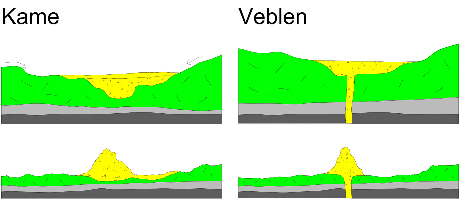
The [layer] of drift is shaped into a wide variety of structures, [kames, eskers, rimmed plateaus, drumlins, flutings, striations, potholes & erratics, as follows below]....
<<__Question 3 for Gordon: Can you explain how a megatsunami could produce each of the drift types discussed below, i.e. kames, eskers, rimmed plateaus, drumlins, flutings, striations, potholes & erratics? Or can you give a source that explains them all?>
Images of kames, eskers, rimmed plateaus, drumlins, flutings, striations, potholes & erratics:
Kame: https://www.dmr.nd.gov/ndgs/ndnotes/Veb ... 20copy.jpg
Esker: http://8c4625.medialib.glogster.com/med ... ission.jpg
Drumlin: http://www.geo-logic.org/Glacial%20Geol ... eum.ca.gif
Fluting: http://3.bp.blogspot.com/-_7CSUyHA0I8/T ... luting.jpg
Striations: https://c1.staticflickr.com/7/6174/6139 ... 683e_b.jpg
Potholes: https://s3.amazonaws.com/gs-geo-images/ ... 8f5b75.jpg
Erratics: http://media-2.web.britannica.com/eb-me ... aOeS82.jpg
KAMES
Kames are conical mounds usually composed of sandy material.
<Glacial Theory> [Kames] are thought to have been caused by the dumping of glacial debris when the great ice sheets of the glacial age melted.
ESKERS
Eskers are long, winding ridges of gravel and sand.... Sometimes branching eskers occur. The eskers are known to stretch for great distances, go up and down hills, and disappear and occur again further on.
<Glacial Theory> [Eskers] are explained in the glacial theory as the debris of rivers formed in or on the glaciers, that was let down when the ice melted.
RIMMED PLATEAUS
In the prairie regions of Canada and in the northern states of the United States there are various kinds of rimmed plateau[s], composed of drift. Often these have central depressions containing clay sediments. The rims are often composed of stony material and contorted drift layers. Some of the rimmed plateau[s] or prairie mounds are of large size, with areas of several square miles, and may reach as much as 150 feet above the surrounding hummocky and pitted regions.
Hummocky: http://www.seddepseq.co.uk/SEDIMENTOLOG ... mmock1.jpg
<Glacial Theory> The rimmed plateau[s] and prairie mounds are explained in the glacial theory as landforms created during the melting of the great ice-sheets. The glaciers, it is believed, sometimes melted in such a way that isolated blocks of ice were formed, that wasted away and deposited their debris in various kinds of rimmed structures and plateau[s].
DRUMLINS, FLUTINGS
Drumlins are hills shaped like the inverted bowl of a spoon.... Glacial flutings are similar, elongated parallel ridges and troughs. Individual flutings may stretch for several miles in the prairies of Canada and parts of North Dakota and Montana.
Drumlins and flutings are ... streamlined landforms ... often composed of drift, but many are bedrock or partly bedrock. Some have a mass of bedrock at their upstream ends. ... In drumlin swarms the drumlins all have locally parallel orientation ... sometimes covering thousands of square miles.
<Glacial Theory> Drumlins and flutings are explained as the effects of the movement of the ice in the glacial theory. The ice-sheet flowing across the countryside shaped and moulded the rocks and previously deposited layers of glacial debris into these remarkable ... landforms....
<<__Question 4 for Gordon: Could the parallel Nebraska dunes be drumlins or flutings? Is there any way an ice sheet could move significantly and streamline any of these drift types?>
STRIATIONS
Striations are frequently present on the surface of the bedrock underlying the layer of drift. In some areas the bare rocks uncovered by drift are also scratched and grooved, as if by movement of stones across them.... Within the layers of gravel in the drift there are many rocks and boulders that are striated.
<Glacial Theory> These are thought to have been transported by ice and abraded in the process. ... [Bedrock surface striations are] attributed to the ice-sheets in the glacial theory [with] large numbers of stones being carried along in its base, that gouged the bedrock as the ice-sheet went along.
<<__Question 5 for Gordon: How could megatsunamis make striations on bedrock and on the rocks that they push around?>
POTHOLES
In the bedrock underneath the drift, and at many places where the bedrock is exposed, there are deep vertical potholes, ... usually filled up with the drift material, sand and gravel and large boulders.
<Glacial Theory> [Potholes] are often explained by reference to the glacial theory. These are attributed to glacial "moulins" or waterfalls tumbling down crevasses in the ice, that eroded the bedrock and caused these deep holes.
<<__Question 6 for Gordon: The Washington scablands that formed from the Missoula flood have potholes that formed by vortex cavitation during the flood, apparently, so were potholes in bedrock under the drift more likely form from flood than from glaciation? Are the scabland potholes ever filled with drift? Maybe this image answers the question: http://www.paddling.net/sameboat/Images ... oles10.jpg >
ERRATICS
Large boulders, ... known as "erratics" ..., are found in some regions with a composition quite different from that of the bedrock [and other drift] in the vicinity. These may sometimes be as large as houses, and are usually rounded, though some are of irregular shape. In the drift there are stones and pebbles of varying composition and appearance, but most of the rocks reflect the composition of the bedrock underneath.
<Glacial Theory> The large boulders ... are considered to have been transported from regions afar by the moving ice-sheets. ...
<<__Question 7 for Gordon: Why is most drift of the same rock type as the bedrock under it? If the flood transported large erratic boulders, shouldn't smaller kinds of drift material also be erratic?>
... ... Flint provides a table of some examples of ... erratics ... [here modified & supplemented]:
Erratics
Moved .. Uplifted
distance: height: .. From:
> 18 km; 1000 m; Mount Katahdin, Maine
> 100 km; 900 m; Adirondack Mountains, New York
160 km; 500 m; Allegheny Plateau, central New York
80 km; .. 900 m; Killington Peak, Green Mountains, Vermont
1,300 km; 1,300 m; Rocky Mountains of Alberta
Moved dist: .. To: .... From:
100-1250 km; UK-Russia; Scandinavia & Finland
1000 km; .... Missouri; Ontario
... km; ..............; Alberta
... km; ..............; Manitoba
... km; ..............; Northwest Territories
... km; ..............; [Ireland &] Wales
... km; ..............; Northern Germany
These erratics, [many] perched higher than their sources, if they are to be attributed to ice, would require that the direction of the flow of the ice was opposite to the slope of the land. Flint suggested that the stones were carried in the base of the ice, which flowed uphill, rather than that they somehow migrated upwards through the ice. ... How Could the Ice Move Uphill?... Howorth accused the glacialists of departing from the principles of physics and appealing to "transcendental causes". ... Howorth believed that the motivation of geologists who favored the glacial theory was their reluctance to accept a catastrophic alternative. ... In his book Ice or Water he [said:] ... Their real inspiration has been the fervent hope embodied in the words with which Sir R. Ball concludes his ill-fated book on the Glacial Age. "The appeal to ice removed the glacial period from the position of a 'catastrophic' phenomenon. It placed the ice-sheet as an implement at the disposal of the geological uniformitarian."
Problems in the Glacial Theory
Creation Research Society Quarterly, 13(1):25-34, June 1976
[Note: I'm not a creationist, but they published a lot of good science. I suspect that the great majority of glacial evidence is actually great flood evidence as this article explains.]
DRIFT
... A layer of unconsolidated material [called drift] ... covers the solid sedimentary and igneous rocks in the temperate zones of Europe and North America. ... A ... similar [layer] occurs in parts of India, in South Africa, the tropical zones of South America, and in many mountainous areas of the world.
<<__Question 1 for Gordon: Do you agree that the drift in India, S Africa & S America suggests that the drift layer was deposited before the supercontinent split, because those 3 areas were adjacent on the supercontinent? Europe & N America were also adjacent. I wonder if the other mountainous areas containing drift are adjacent to both of those two north & south locations.>>
<<__Question 2 for Gordon: Why did the drift not lithify during the flood? Is there any other significant amount of drift that wasn't deposited by the Great Flood? And why are there locations with no drift?>
The material consists of gravel, sand and clay, with many large boulders of variable composition, and innumerable rounded stones and pebbles of all sizes. Often it is hundreds of feet thick. Frequently stratification exists, and it is usually present in the sand in the pattern of cross stratification.
Cross stratification: http://www.earth.northwestern.edu/indiv ... sstrat.gif
Usually referred to as "drift", the material is also known as boulder-clay, diluvium, outwash deposits, glacial moraine, and till. ... In general, the landforms composed of drift have a remarkably fresh appearance. Although they contain loose material, the effects of erosion have been minimal, showing they could not be of great age but must have been formed recently.
<Glacial Theory> Geologists believe that the last of the ice disappeared only a few thousand years ago.
The [layer] of drift is shaped into a wide variety of structures, [kames, eskers, rimmed plateaus, drumlins, flutings, striations, potholes & erratics, as follows below]....
<<__Question 3 for Gordon: Can you explain how a megatsunami could produce each of the drift types discussed below, i.e. kames, eskers, rimmed plateaus, drumlins, flutings, striations, potholes & erratics? Or can you give a source that explains them all?>
Images of kames, eskers, rimmed plateaus, drumlins, flutings, striations, potholes & erratics:
Kame: https://www.dmr.nd.gov/ndgs/ndnotes/Veb ... 20copy.jpg
Esker: http://8c4625.medialib.glogster.com/med ... ission.jpg
Drumlin: http://www.geo-logic.org/Glacial%20Geol ... eum.ca.gif
Fluting: http://3.bp.blogspot.com/-_7CSUyHA0I8/T ... luting.jpg
Striations: https://c1.staticflickr.com/7/6174/6139 ... 683e_b.jpg
Potholes: https://s3.amazonaws.com/gs-geo-images/ ... 8f5b75.jpg
Erratics: http://media-2.web.britannica.com/eb-me ... aOeS82.jpg
KAMES
Kames are conical mounds usually composed of sandy material.
<Glacial Theory> [Kames] are thought to have been caused by the dumping of glacial debris when the great ice sheets of the glacial age melted.
ESKERS
Eskers are long, winding ridges of gravel and sand.... Sometimes branching eskers occur. The eskers are known to stretch for great distances, go up and down hills, and disappear and occur again further on.
<Glacial Theory> [Eskers] are explained in the glacial theory as the debris of rivers formed in or on the glaciers, that was let down when the ice melted.
RIMMED PLATEAUS
In the prairie regions of Canada and in the northern states of the United States there are various kinds of rimmed plateau[s], composed of drift. Often these have central depressions containing clay sediments. The rims are often composed of stony material and contorted drift layers. Some of the rimmed plateau[s] or prairie mounds are of large size, with areas of several square miles, and may reach as much as 150 feet above the surrounding hummocky and pitted regions.
Hummocky: http://www.seddepseq.co.uk/SEDIMENTOLOG ... mmock1.jpg
<Glacial Theory> The rimmed plateau[s] and prairie mounds are explained in the glacial theory as landforms created during the melting of the great ice-sheets. The glaciers, it is believed, sometimes melted in such a way that isolated blocks of ice were formed, that wasted away and deposited their debris in various kinds of rimmed structures and plateau[s].
DRUMLINS, FLUTINGS
Drumlins are hills shaped like the inverted bowl of a spoon.... Glacial flutings are similar, elongated parallel ridges and troughs. Individual flutings may stretch for several miles in the prairies of Canada and parts of North Dakota and Montana.
Drumlins and flutings are ... streamlined landforms ... often composed of drift, but many are bedrock or partly bedrock. Some have a mass of bedrock at their upstream ends. ... In drumlin swarms the drumlins all have locally parallel orientation ... sometimes covering thousands of square miles.
<Glacial Theory> Drumlins and flutings are explained as the effects of the movement of the ice in the glacial theory. The ice-sheet flowing across the countryside shaped and moulded the rocks and previously deposited layers of glacial debris into these remarkable ... landforms....
<<__Question 4 for Gordon: Could the parallel Nebraska dunes be drumlins or flutings? Is there any way an ice sheet could move significantly and streamline any of these drift types?>
STRIATIONS
Striations are frequently present on the surface of the bedrock underlying the layer of drift. In some areas the bare rocks uncovered by drift are also scratched and grooved, as if by movement of stones across them.... Within the layers of gravel in the drift there are many rocks and boulders that are striated.
<Glacial Theory> These are thought to have been transported by ice and abraded in the process. ... [Bedrock surface striations are] attributed to the ice-sheets in the glacial theory [with] large numbers of stones being carried along in its base, that gouged the bedrock as the ice-sheet went along.
<<__Question 5 for Gordon: How could megatsunamis make striations on bedrock and on the rocks that they push around?>
POTHOLES
In the bedrock underneath the drift, and at many places where the bedrock is exposed, there are deep vertical potholes, ... usually filled up with the drift material, sand and gravel and large boulders.
<Glacial Theory> [Potholes] are often explained by reference to the glacial theory. These are attributed to glacial "moulins" or waterfalls tumbling down crevasses in the ice, that eroded the bedrock and caused these deep holes.
<<__Question 6 for Gordon: The Washington scablands that formed from the Missoula flood have potholes that formed by vortex cavitation during the flood, apparently, so were potholes in bedrock under the drift more likely form from flood than from glaciation? Are the scabland potholes ever filled with drift? Maybe this image answers the question: http://www.paddling.net/sameboat/Images ... oles10.jpg >
ERRATICS
Large boulders, ... known as "erratics" ..., are found in some regions with a composition quite different from that of the bedrock [and other drift] in the vicinity. These may sometimes be as large as houses, and are usually rounded, though some are of irregular shape. In the drift there are stones and pebbles of varying composition and appearance, but most of the rocks reflect the composition of the bedrock underneath.
<Glacial Theory> The large boulders ... are considered to have been transported from regions afar by the moving ice-sheets. ...
<<__Question 7 for Gordon: Why is most drift of the same rock type as the bedrock under it? If the flood transported large erratic boulders, shouldn't smaller kinds of drift material also be erratic?>
... ... Flint provides a table of some examples of ... erratics ... [here modified & supplemented]:
Erratics
Moved .. Uplifted
distance: height: .. From:
> 18 km; 1000 m; Mount Katahdin, Maine
> 100 km; 900 m; Adirondack Mountains, New York
160 km; 500 m; Allegheny Plateau, central New York
80 km; .. 900 m; Killington Peak, Green Mountains, Vermont
1,300 km; 1,300 m; Rocky Mountains of Alberta
Moved dist: .. To: .... From:
100-1250 km; UK-Russia; Scandinavia & Finland
1000 km; .... Missouri; Ontario
... km; ..............; Alberta
... km; ..............; Manitoba
... km; ..............; Northwest Territories
... km; ..............; [Ireland &] Wales
... km; ..............; Northern Germany
These erratics, [many] perched higher than their sources, if they are to be attributed to ice, would require that the direction of the flow of the ice was opposite to the slope of the land. Flint suggested that the stones were carried in the base of the ice, which flowed uphill, rather than that they somehow migrated upwards through the ice. ... How Could the Ice Move Uphill?... Howorth accused the glacialists of departing from the principles of physics and appealing to "transcendental causes". ... Howorth believed that the motivation of geologists who favored the glacial theory was their reluctance to accept a catastrophic alternative. ... In his book Ice or Water he [said:] ... Their real inspiration has been the fervent hope embodied in the words with which Sir R. Ball concludes his ill-fated book on the Glacial Age. "The appeal to ice removed the glacial period from the position of a 'catastrophic' phenomenon. It placed the ice-sheet as an implement at the disposal of the geological uniformitarian."
-
GaryN

- Posts: 2668
- Joined: Tue Apr 01, 2008 8:18 pm
- Location: Sooke, BC, Canada
Re: Evidence of Ancient Global Cataclysm
The cobbles in that pothole will be found to be still attached to the bedrock, I have lots of images of the same kind of thing. The cobbles are of a different composition to the bedrock, basalt in my case, which means they were created and metamorphosed just where they now are. Forget water or glaciers, ALL rounded pebbles, cobbles, boulders were created by EM means in a split second.<<__Question 6 for Gordon: The Washington scablands that formed from the Missoula flood have potholes that formed by vortex cavitation during the flood, apparently, so were potholes in bedrock under the drift more likely form from flood than from glaciation? Are the scabland potholes ever filled with drift? Maybe this image answers the question: http://www.paddling.net/sameboat/Images ... oles10.jpg >
https://www.flickr.com/photos/garyinsoo ... 766895323/
In order to change an existing paradigm you do not struggle to try and change the problematic model. You create a new model and make the old one obsolete. -Buckminster Fuller
-
webolife

- Posts: 2539
- Joined: Mon Mar 17, 2008 2:01 pm
- Location: Seattle
Re: Evidence of Ancient Global Cataclysm
Drift is more the result of a drainage process than of a deluvial one. But which I mean [and claim] that the underlying sedimentary formations were eroded by waters draining off in the last stages of the flood event[s].
The materials largely derive from the underlying formations, unlike the case of erratics which are carried by [probably] continental glaciation from a more distant formation, eg. granite from the Canadian Cascades landed in the Willamette Valley in Oregon. So in the case of drift found on facing sides of separated continents, I suggest that the various agents of the flood [not only the tsunami action which you have taken to focusing on] laid the underlying sediments in a similar fashion on the lowlands of the [two] spreading continental masses, then the later drainage action left the drift as a superficial feature, after the majority of the spreading was done.
I have little reason to doubt that major continental glaciation happened across the young continents in the later stage[s] of the flood and afterwards, and that other drainage related phenomena also occurred at this time, ie. at the end of and after the flooding. Glacial advance seems a good mechanism for the creation of drumlins, striations and such, while glacial retreat seems a suitable [and observable] mechanism for the deposit of kames and eskers and other types of mounds, as well as the very common and relatively superficial outwash deposits[till]. Drumlins are not dunes. Windblown deposits are a result of the global wind development that happened after [as a result of] the flood dynamics, while the potholes and coulees of the Pacific Northwest [Eastern Washington] happened during the later retreat of the glaciation, with the breakage of an ice dam at glacial Lake Missoula. I place the retreat of the glaciation largely in the few centuries after the flood, and after the continental drift surge.
Truth extends beyond the border of self-limiting science. Free discourse among opposing viewpoints draws the open-minded away from the darkness of inevitable bias and nearer to the light of universal reality.
-
webolife
- Posts: 2539
- Joined: Mon Mar 17, 2008 2:01 pm
- Location: Seattle
Re: Evidence of Ancient Global Cataclysm
I think I disagree with Gary's assessment of the included pebbles in the potholes. In studying eastern Washington potholes, and other hilly basalt areas where pebbles are also found, I find rather that water action is likely responsible for the placement of these stream-rounded non-basalt rocks. In the case of smaller potholes, as were pictured above, the pebbles are agents of cavitation, and as they are forcefully slammed into the basalt by the vertical action, they can become lodged... this is an usual occurrence, but when I've seen it, the pebbles are wedged into crevices or other openings in vesicular basalt, or just laying on the floor of or surrounding the rim of larger potholes. The potholes I studied are those adjacent to Deep Lake in the Sun Lakes State Park, and the hilly areas were south of Vantage around Mattawa, where I hiked to collect petrified wood samples.
Truth extends beyond the border of self-limiting science. Free discourse among opposing viewpoints draws the open-minded away from the darkness of inevitable bias and nearer to the light of universal reality.
-
Brigit Bara

- Posts: 643
- Joined: Tue Dec 30, 2008 1:37 pm
Re: Evidence of Ancient Global Cataclysm
GaryN says,
But there is an important alternative explanation to almost all of the evidence which was originally put forward for glacial retreat--that is, striation, glacial till and erratics.
From Another Big Blue Marble
Posted on January 10, 2014 by Stephen Smith
Though I have not visited the scablands, we do live nearby and have subjected ourselves to the documentaries. The dam which had to have held the amount of water needed to carve out the area is so stupendous, it is what allynh calls "a just so story." The flood explanations are also utilized to explain some of our local waterfalls along the Columbia River, where we have highly stratified layers of basalt which tower to hundreds of feet in places, and just a few feet in other places.
In the Columbia River Gorge, in the Columbia Plateau, an electrical explanation is superior to missing hot spots and volcanoes, combined with massive floods to wear some areas down while leaving others towering close by.
The EU resources on geology and archaeology do have plenty of mentions of the ice age/s.The cobbles are of a different composition to the bedrock, basalt in my case, which means they were created and metamorphosed just where they now are. Forget water or glaciers, ALL rounded pebbles, cobbles, boulders were created by EM means in a split second.
But there is an important alternative explanation to almost all of the evidence which was originally put forward for glacial retreat--that is, striation, glacial till and erratics.
From Another Big Blue Marble
Posted on January 10, 2014 by Stephen Smith
While I haven't tried to link river rocks to electrical discharges, I do agree with Gary N that a high temperature, rapid process is in evidence in our river systems in the Northwest, and in the scablands, and water doesn't cut it.As orbits adapt to a new stable configuration, dust, stones and boulders arriving from space or blasted from distant parts of the same body are deposited. Plasma etching, combined with ionic discharges, are responsible for rounding the rocks, scattering them uniformly across the landscape, and leaving “flow streaks” from electrical “winds.” Blowing gases and flowing liquids require action over long spans of time. Electrical erosion, caused by forces billions of times stronger than mechanical forces, can achieve observed effects in short times.
Though I have not visited the scablands, we do live nearby and have subjected ourselves to the documentaries. The dam which had to have held the amount of water needed to carve out the area is so stupendous, it is what allynh calls "a just so story." The flood explanations are also utilized to explain some of our local waterfalls along the Columbia River, where we have highly stratified layers of basalt which tower to hundreds of feet in places, and just a few feet in other places.
In the Columbia River Gorge, in the Columbia Plateau, an electrical explanation is superior to missing hot spots and volcanoes, combined with massive floods to wear some areas down while leaving others towering close by.
“Oh for shame, how these mortals put the blame upon us gods, for they say evils come from us, when it is they rather who by their own recklessness win sorrow beyond what is given…”
~Homer
~Homer
-
Brigit Bara
- Posts: 643
- Joined: Tue Dec 30, 2008 1:37 pm
Re: Evidence of Ancient Global Cataclysm
To attempt to give some idea of the incoherence of the geology along the Columbia, here are two peaks at the same height above sea level, and showing the same erosional pattern--

As you can see, the peak on the left is igneous and the peak on the right is sedimentary.
One might expect that gravity would dictate a predictable pattern of deposition for the igneous rock here. And in some ways it seems to conform to a volcanic flow pattern. But in fact the two peaks above illustrate more of the rule than the exception. There are extraordinarily rapid transitions all along the length of the river from basalt to other bedding. These all occur at the same altitude and many times within each mile.
This and other features are what one would expect if this whole River system is a gigantic fulgarite.
“Oh for shame, how these mortals put the blame upon us gods, for they say evils come from us, when it is they rather who by their own recklessness win sorrow beyond what is given…”
~Homer
~Homer
-
Lloyd
- Posts: 4433
- Joined: Fri Apr 04, 2008 2:54 pm
Re: Evidence of Ancient Global Cataclysm
You guys are giving me a lot to think about. I started doubting EU theory about electrical forces carving Earth features etc, when I learned that there were two huge lakes that breached at the points where the Grand Canyon starts. I previously thought it was plausible that arc discharge carved the canyon, but it would be way too much of a coincidence that those two huge lakes just happened to be there and the canyon just happens to have formed where the lake shores breached. Most folks here don't seem to change their minds in light of new or more detailed findings. I differ.
Gary, your info is interesting, but Gordon explains it in part, and I can imagine rocks of different composition becoming attached to or enmeshed in sedimentary rock, such as potholes, when the latter is not yet lithified.
Gordon, what evidence is there that glaciers can haul boulders (erratics) hundreds of miles up slopes? Can you give any references to books etc that show good evidence that the various types of drift were formed by glacial forces? And can you answer Brigit?
Brigit and Gary, TPODs have shown the thunderbolt in ancient myths to have had a lens-like shape. Do either of you know of mention of myths etc that show other forms of electrical energy? That lens-shaped form seems to indicate a very limited range of discharge or brightening, not a discharge from planetoid to Earth etc. Velikovsky mentioned a Greek myth that one of the gods caught two other gods in a net, which seems like it might be more of what EU theory supposes, but so far the EU theory of electrical carving of major features on Earth seems unlikely. Charles explained once that Ransom's experiment of forming blueberries with electricity is comparable to the beads formed in common welding, which is simply heated, molten metal.
-------------------------------------
WALTER BROWN'S FLOOD INFO
I don't find Brown's Hydroplate theory to be plausible, but his online book has a lot of good flood info, so I'll post some of it.
LIQUEFACTION
Liquefaction During the Flood
SUMMARY: Liquefaction ... played a major role in rapidly sorting sediments, plants, and animals during the flood. Indeed, the worldwide presence of sorted fossils and sedimentary layers shows that a gigantic global flood occurred. Massive liquefaction also left other diagnostic features such as cross-bedded sandstone, plumes, mounds, and fossilized footprints.
The Origin of Strata and Layered Fossils
What would happen to buried animals and plants in temporarily liquefied sediments?
As we will see, fluid-like sediments produced a buoyancy that largely explains why fossils show a degree of vertical sorting and why sedimentary rocks all over the world are typically so sharply layered. During liquefaction [common with water saturated soil during earthquakes], denser particles sink and lighter particles (and dead organisms, soon to become fossils) float up — until a liquefaction lens is encountered. Lenses of water form along nearly horizontal paths if the sediments below those horizontal paths are more permeable than those above, so more water flows up into each lens than out through its roof. Sedimentary particles and dead organisms buried in the sediments were sorted and resorted into vast, thin layers.
STRATA FORMATION
A sedimentary layer often spans hundreds of thousands of square miles. (River deltas, where sediment thicknesses grow most rapidly [in modern times], are a tiny fraction of that area.) Liquefaction during a global flood would account for the vast expanse of these thick layers. Current processes and eons of time do not.
One thick, extensive sedimentary layer has remarkable purity. The St. Peter sandstone, spanning about 500,000 square miles in the central United States, is composed of almost pure quartz, similar to sand on a white beach. It is hard to imagine how any geologic process, other than global liquefaction, could achieve this degree of purity over such a wide area.21 Almost all other processes involve mixing, which destroys purity.
Today, sediments are usually deposited in and by rivers — along a narrow line. However, individual sedimentary rock layers are spread over large geographical areas, not on long narrow, streamlike paths. Liquefaction during the flood acted on all sediments and sorted them over wide areas in weeks or months.
FOSSIL ORDER
[An] experiment showed that the natural order of settling following death was, from the bottom up: amphibian, reptile, mammal, and finally bird.18 This order of relative buoyancy correlates closely with “the evolutionary order,” but, of course, evolution was not the cause. Other factors, also influencing burial order at each geographical location, were: liquefaction lenses; which animals were living in the same region; and each animal’s mobility before the flood overtook it.
FLATTENED FOSSILS BETWEEN THIN LAYERS
Many fossilized fish are flattened between extremely thin sedimentary layers. This requires squeezing the fish to the thinness of a sheet of paper without damaging the thin sedimentary layers directly above and below. How could this happen? Because dead fish usually float, something must have pressed the fish onto the seafloor. Even if tons of sediments were dumped through the water and on top of the fish, thin [flat] layers would not lie above and below the fish. Besides, it would take many thin layers, not one, to complete the burial. We do not see this happening today. However, liquefaction would sort sediments into thousands of thin layers. During each wave cycle, liquefaction lenses would simultaneously form at various depths in the sedimentary column. Fish that floated up into a water lens would soon be flattened when the lens finally drained. [Water hammers and flutter vibrated the sediments as explained below.]
... WATER HAMMERS ...
Water hammers occur, often with a loud bang, when a fluid flowing in a pipe is suddenly stopped (or slowed) by closing (or narrowing) a valve, such as a faucet. A water hammer is similar to the collision of a long train. The faster and more massive the flowing volume of water, the greater the sudden compression (or pressure pulse) throughout the pipe as the water is slowed or stopped. A water hammer concentrates energy, just as a hammer striking a nail concentrates energy and produces forces many times greater than a resting hammer.
FLUTTER
Vibrations often begin when a fluid (a liquid or gas) flows along a relatively thin, flexible surface, such as the wing of an airplane or a flat plate. If (a) the flowing fluid continually “thumps” or pushes the flexible surface back toward its neutral position, and (b) the “thumping” frequency approaches any natural frequency of the wing or plate, large, potentially damaging oscillations (or resonances), called flutter, can occur.
Water [moving] beneath earth’s crust [in large caves and aquifers along with tidal waves over the crust] during the flood caused the crust to flutter, and its large area gave it great flexibility. Each narrowing of the subsurface flow channel by the vibrating crust slowed [vast amounts] of water and produced water hammers that “thumped” the crust at each of its natural frequencies. Undulations rippled throughout the crust, producing other water hammers, more undulations, pulsations ..., and huge flutter amplitudes. Most people have heard water pipes banging or have seen pipes burst when only a few cubic feet of water were slowed. Imagine the excruciating pressures from rapidly slowing a “moving underground ocean.”12
SEDIMENT SOURCE/S
Sediments, such as sand and clay, are produced by eroding crystalline rock, such as granite or basalt. Sedimentary rocks are cemented sediments. On the continents, they average more than a mile in thickness. Today, two-thirds of continental surface rocks are sedimentary; one-third is crystalline. Was crystalline rock, eroded at earth’s surface, the source of the original sediments? If it was, the first blanket of eroded sediments would prevent that rock from producing additional sediments. The more sediments produced, the fewer the sediments that could be produced. Exposed crystalline rock would disappear long before all today’s sediments and sedimentary rocks could form. Transporting those new sediments, often great distances, is another difficulty. Clearly, most sediments did not come from the earth’s surface. ...
[I see 4 possibilities for the source of sand and clay sediments. They could have come from:
1. erosion of the granite continental shelf of the supercontinent;
2. erosion of the basalt ocean floor;
3. erosion of subsurface granite or basalt;
4. precipitation of detritus from space.
The first is Baumgardner's theory. The second is other creationists' view. The third is Brown's. The last is Cardona's, with Saturn flares being the specific source. #1 seems the most plausible, since megatsunamis caused by a planetoidal/asteroidal tidal pull would mostly affect the supercontinental shelf, probably in the western Pacific around Asia. Baumgardner explained that high velocity water, as in a megatsunami, causes cavitation, which can rapidly erode solid rock via vacuum pressure. But the shelf may also have contained a lot of sand and clay from normal rain erosion of the supercontinent for thousands or millions of years. That could be moved even more easily by "tidal waves".]
MOUNDS
Liquefaction Plumes and Mounds. The large water content of liquefied sand layers (40%) would have made them quite buoyant. Whenever a low-density, fluid layer (such as a water-sand mixture) underlies a denser, liquefied layer, the lighter fluid, if shaken, will float up in plumes through the denser fluid. Sand plumes that penetrated overlying layers are seen in many places on earth.
During the [flood], liquefied water-sand mixtures in many places erupted like small volcanoes. Being surrounded and permeated by water, they would have quickly slumped into the shape of an upside-down bowl — a liquefaction mound. As the flood waters drained at the end of the flood, most liquefaction mounds were swept away, because they did not have time to be cemented. However, mounds inside postflood lakes (basins) were cemented as each lake cooled and its dissolved silica and calcium carbonate were forced out of solution. If a lake later breached and dumped its water, the larger cemented mounds could resist the torrent of rushing water and retain their shapes. The basins that held Grand and Hopi Lakes contain hundreds of such mounds. The sudden breaching of those lakes several centuries after the flood carved the Grand Canyon.
Ayers Rock ... in central Australia ... has characteristics of both a broad liquefaction plume and a liquefaction mound.
Missing Mesozoic STRATUM
Actually, cutting through the Kaibab Plateau is a relatively minor problem, and carving the entire Grand Canyon is not even half the problem. The Grand Canyon’s rim consists of hard Kaibab Limestone, typically 350 feet thick. When you walk to the canyon’s edge to look down, you are standing on Kaibab Limestone. It extends away from the canyon in all directions, covering about 10,000 square miles. However, rising 1,000 feet above this Kaibab Limestone at a few dozen isolated spots are softer (crumbly or weakly cemented) Mesozoic rocks; they are always capped on top by a very hard rock, such as lava. Obviously, lava did not flow up to the top; lava, which flows downhill, collected in a depression and hardened. Later, a fast-moving sheet of water flowed over northern Arizona and swept all the soft Mesozoic rock off the hard Kaibab Limestone — except for the few dozen spots capped and protected by hard rock.
Why must it have been a sheet of water? Falling rain would cut only channels. Flowing rivers or streams, even if they meandered for millions of years, would not uniformly sweep 1,000 feet or more of material off almost all of these 10,000 square miles of the fairly flat Kaibab Limestone. Besides, meandering rivers would produce meandering patterns. Therefore, before you can excavate 800 cubic miles of rock below the rim to form the Grand Canyon, something must sweep off almost all the Mesozoic rock above — a much larger excavation project. Surprisingly, the Mesozoic rock has also been swept off the Kaibab Plateau. How could water get so high? Maybe the sweeping process — the Great Denudation — occurred before the Kaibab Plateau rose. [YES! The plateau and all mountain ranges were uplifted after a large asteroid impact split up the supercontinent, apparently a short time after the flood.]
Petrified Forest.
Probably the world’s largest concentration of petrified wood is in the Petrified Forest National Park in Arizona. (Trainloads of petrified wood were removed before the region became a protected park in 1906.) Few people realize that this park lies inside the former Hopi Lake. Why does wood petrify, and how were these unusual conditions met in Hopi Lake?
Researchers using silica-rich solutions have duplicated petrification in laboratories. [In the flood] (1) ... silica ... was dissolved in the hot subterranean water and (2) ... large preflood trees58 [were] floating in warm postflood lakes....
“... silica nucleation and deposition can occur directly and rapidly on exposed cellulose surfaces.” Sigleo, p. 1404.
“The majority of these trees [in Petrified Forest National Park] were very tall. On the average the logs are about 80 to 100 feet long and three to four feet in diameter, but some range up to 200 feet in length and ten feet in diameter at the base.” Sidney Ash, Petrified Forest: The Story Behind the Scenery (Holbrook, Arizona: Petrified Forest Museum Association, 1985), p. 20.
-
GaryN
- Posts: 2668
- Joined: Tue Apr 01, 2008 8:18 pm
- Location: Sooke, BC, Canada
Re: Evidence of Ancient Global Cataclysm
Grand Canyon Carved by Flood? Geologist Says NoI started doubting EU theory about electrical forces carving Earth features etc, when I learned that there were two huge lakes that breached at the points where the Grand Canyon starts.
- See more at: http://www.livescience.com/25640-grand- ... Y50Ds.dpufCould the origins of the Grand Canyon lie in an enormous flood?
The answer is no, says geologist Bill Dickinson, an emeritus professor of geology at the University of Arizona in Tucson.
Of course I don't agree with his millions of years models either if rivers can be formed instantly by giant surface discharges. The age of rivers is very speculative, as with the so called New River.
Geology of New River Gorge
https://www.nps.gov/neri/learn/nature/geology.htm..We've just learned how the river cut its gorge, but how long did it take? Geologists don't know, and their estimates vary widely from 3 million years to 320 million years.
How long ago it was formed is anyones guess, I do believe the periodic catatrophes may vary greatly in magnitude, and discharges may have occurred along the same trackways a number of times, eroding and deepening the gorges each time, but that's just as much speculation as the standard model. Andrew Hall is on the correct track, these events were likely of very great scale, from our tiny perspective anyway.
In order to change an existing paradigm you do not struggle to try and change the problematic model. You create a new model and make the old one obsolete. -Buckminster Fuller
-
Brigit Bara
- Posts: 643
- Joined: Tue Dec 30, 2008 1:37 pm
Re: Evidence of Ancient Global Cataclysm
Thank you for saying so! I previously suspected that many catastrophists here had completely ruled out the role of electricity in sculpting the earth's surface features. So now we know.post by Lloyd » Wed Jun 08, 2016 10:49 am
You guys are giving me a lot to think about. I started doubting EU theory about electrical forces carving Earth features etc, when I learned that there were two huge lakes that breached at the points where the Grand Canyon starts. I previously thought it was plausible that arc discharge carved the canyon, but it would be way too much of a coincidence that those two huge lakes just happened to be there and the canyon just happens to have formed where the lake shores breached. Most folks here don't seem to change their minds in light of new or more detailed findings. I differ.
Strictly speaking, the EU theory is not that "electrical forces carved Earth's features." The Electric Universe theory is that electrical forces have scarred all of the surfaces of the planets and moons in the solar system. In this case craters are electrically formed, which explains many characteristics of craters that no mere mechanical impact could produce. But there are other forms of electrical scarring in the solar system. There are mountains, mountain chains, hummocks, dunes, buttes, canals, rilles and dendritic systems. These compare well with the same features on earth. The question for water-only catastrophists is, "Did continental drift, volcanoes, and flood water form the same features on the moons, asteroids and other planets too?"
As Stephen Smith's POTDs have pointed out many times, the discoveries and images from space are best used to interpret the surface of the earth, rather than the earth's surface being used to interpret what we see in space. So, for example, the Grand Canyon and the Valles Marineris on Mars are compared and carefully studied as possible scars left by a previous electrical encounter.

holoscience
While a couple of theorized lake beds here and there may suffice for water-only catastrophists, in my opinion this is only because they are accustomed to strictly limiting themselves to earthly geology. Electrical forces have explanatory power for the rest of the solar system as well as the home planet.
“Oh for shame, how these mortals put the blame upon us gods, for they say evils come from us, when it is they rather who by their own recklessness win sorrow beyond what is given…”
~Homer
~Homer
-
Brigit Bara
- Posts: 643
- Joined: Tue Dec 30, 2008 1:37 pm
Re: Evidence of Ancient Global Cataclysm
Lloyd says,
"You guys are giving me a lot to think about."
You provided a lot of food for thought too. I did read the rest of the post, esp. regarding fossils in thinly lithified beds, and water sorting of sedimentary layers. Also, the idea that the stone spheres formed by CjRansom and WThornhill in the lab are simply round because they are melted is interesting. This implies that they are merely an analogue to "lava bombs."
It would be good fun to address these during the month of June. Not on NIMA though.
“Oh for shame, how these mortals put the blame upon us gods, for they say evils come from us, when it is they rather who by their own recklessness win sorrow beyond what is given…”
~Homer
~Homer
-
katesisco
- Posts: 96
- Joined: Sat Apr 19, 2008 9:36 am
Re: Evidence of Ancient Global Cataclysm
This is an excellent idea. I hope to see the current research and the old evidence tied together to have a comprehensive view. We need for this to happen.
http://www.atlantisquest.com/Geology.html
Here is evidence for Greenland's thin continental crust on the southern end as scientists discovered. I realize this is primarily magnetic --I see the Isuua rocks as being the prime mover (literally) for what scientists say is a 15 degree move North and a 15 degree twist in the Earth itself to move Greenland 30 degrees North.
The belief that Greenland was attached at the bottom tip to the coast of Africa very near Gabbon and the natural fission earth reactors requires a strong disbelief in the current process of geology. But it is time for this insight. Back in 2010 Greenland as Atlantis had a lot of sites but they faded. I hope the current discussions at the 2016 EU convention will bring out this connection; perhaps once the Atlantis connection is made everything will fall into place like dominoes.
-
Lloyd
- Posts: 4433
- Joined: Fri Apr 04, 2008 2:54 pm
Re: Evidence of Ancient Global Cataclysm
Sorry I don't have time to discuss more in-depth. I'm visiting friends out of state for a few weeks.
Gary, when the Grand Canyon was formed was, according to the EU team I think, between 14 and 4 thousand years ago. Do you concur?
Brigit, your question for water-only catastrophists is, "Did continental drift, volcanoes, and flood water form the same features on the moons, asteroids and other planets too?"
You've jumped to a conclusion. I'm not a water-only catastrophist. I'm an alternative EU catastrophist. Planetoids, stars, galaxies etc are formed via electrical forces, but not in the way that the EU team has reasoned. Instead, Charles Chandler's model is vastly better. Electrical forces are responsible for the tides, earthquakes, vulcanism, the Moho, continental drift, ionization of comets and meteors etc. Highly charged meteors can explode in air-bursts, or they can cause thermonuclear explosions on impact with land, while also carving rilles etc like Schroeter's Valley on the Moon. Valles Marineris on Mars is likely a rift that occurred during major events there, including the impact that removed its north polar surface, when the volcanoes also erupted. Earth's Great Flood did not involve electrical forces so much, except for the electric tides, which produced the mega-tsunamis, along with a close planetary encounter. I believe in Thoth both Cardona and Talbott agreed that the flood came from the north, but they did not dismiss floods. Cardona thought the polar column vortex released much of those flood waters. Charles' model includes bipolar jets, and Cardona said the polar column was the visible jet on Earth, while the other jet was on the leading side of Saturn, we being on the trailing side.
Kate, I've tried to get such debates going for quite a while, but it seems to be hard for us all to stay organized for that. Charles was doing a good job on his side of a debate, but the EU team experts weren't interested in it. Charles is the opposing expert, but he doesn't seem to have time either these days. I'm always willing to debate, but it'll be a couple weeks or so before I can do much. I only have net access 2 or 3 times a week right now. But I encourage you and anyone else to work on that and I'll try to participate.
Who is online
Users browsing this forum: No registered users and 5 guests