First of all, hello Thunderbolts community, this is my first "real" post and I am very excited to be learning about EU issues.
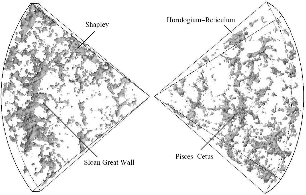
I just wanted to pose the question to you experienced and accomplished folks out there: regarding the "map" of the distribution of galaxies that is shown in the TPOD, I have always had a very hard time trying to understand the data represented in this picture. I've seen this before, on "pop science" tv and elsewhere, but I don't really get it.
Specifically, if each data point represents a galaxy, then why is the coordinate system shown as a pie-slice type shape? Further, this pie-slice axis is labeled with hours of the day. Huh?
Is there a way to get a visualization of the data in a sort of ordinary Cartesian-sort of representation?
Thanks!!
TPOD "Weighing the Void" 10/15/2014
-
AgentP

- Posts: 9
- Joined: Thu Oct 09, 2014 8:06 am
- Location: New England
TPOD "Weighing the Void" 10/15/2014
"...a fellow of infinite jest, of most excellent fancy..."
-
Frantic
- Posts: 255
- Joined: Tue Nov 26, 2013 8:49 am
Re: TPOD "Weighing the Void" 10/15/2014
Well what you are seeing is a survey of the sky based on red-shift determining distance. I think the pie slice is just a field of vision, you are looking at a slice of a 2d image. The point is that the galaxy distribution is filamentary not fitting a gravity based model. So either gravitational models are wrong, or redshift calculations are wrong.
The redshift and distance are actually the same thing in this chart, you are just seeing the distribution as mapped by the sloan sky survey assuming that redshift = distance.
The redshift and distance are actually the same thing in this chart, you are just seeing the distribution as mapped by the sloan sky survey assuming that redshift = distance.
-
AgentP
- Posts: 9
- Joined: Thu Oct 09, 2014 8:06 am
- Location: New England
Re: TPOD "Weighing the Void" 10/15/2014
Frantic,
Thanks for the reply.
So if we look at the "pie slice", we have two radial edges. The left hand is redshift, the right hand is distance. Let's say for sake of argument that we don't think redshift can be mapped on to distance. So we erase the markings along that radial edge, and just have the redshift coordinate. Ok, makes sense.
What I am curious about is the angular coordinate (i.e. the coordinate that corresponds to the out edge of our "pie slice"). The angular coordinate is marked in hours of the day. Why?
Isn't it possible to draw this data in full-360?
"...a fellow of infinite jest, of most excellent fancy..."
-
Frantic
- Posts: 255
- Joined: Tue Nov 26, 2013 8:49 am
Re: TPOD "Weighing the Void" 10/15/2014
Full 360 is impossible because our galaxy prevents us from seeing anything within the plane of our own galaxy. In this data, only a 2d slice with a small amount of depth was recorded, not full 3d.AgentP wrote:Frantic,
Thanks for the reply.
So if we look at the "pie slice", we have two radial edges. The left hand is redshift, the right hand is distance. Let's say for sake of argument that we don't think redshift can be mapped on to distance. So we erase the markings along that radial edge, and just have the redshift coordinate. Ok, makes sense.
What I am curious about is the angular coordinate (i.e. the coordinate that corresponds to the out edge of our "pie slice"). The angular coordinate is marked in hours of the day. Why?
Isn't it possible to draw this data in full-360?
The hours is just another way to measure the angle.
Check this link below, this is what we can see:
http://upload.wikimedia.org/wikipedia/c ... dfdtfe.gif
Also, google, sloan galaxy field survey, and check the images, also check the wiki if you are interested in a little more on it.
-
AgentP
- Posts: 9
- Joined: Thu Oct 09, 2014 8:06 am
- Location: New England
Re: TPOD "Weighing the Void" 10/15/2014
Thanks Frantic! I didn't know it was called the "Sloane Digital Sky Survey" or "Sloane Galaxy Field Survey."
I found the following page helpful:
http://milkyway.cs.rpi.edu/milkyway/science.php
...in particular some of the images.
I think I'm starting to get it.
By the way, having my eyes slowly opened by my readings of EU stuff makes me laugh when I see a picture of the Milky Way surrounded by a drawing labeled "Dark Matter Halo."
"...a fellow of infinite jest, of most excellent fancy..."
Who is online
Users browsing this forum: No registered users and 11 guests